Unidentified Fieldstone Grave Marker (F2-2005)
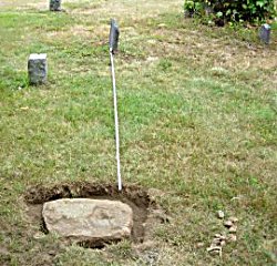
This fieldstone was flush to the ground located aout 8' southeast of Daniel Doane (d1712) who is at Location 36 on the EHS 1976 Cove survey map. In July 2005 the fieldstone was uncovered as shown in the left photo. The 8' tape extends from the Daniel Doane headstone to the uncovered fieldstone.
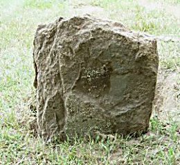
The fieldstone was cleaned and placed upright as shown in the right photo. Dimensions of the entire stone are 19" H, 13" W and 3" D. Dimensions exposed after the stone was set in place are 13" H, 13" W and 3" D. Based on the stone position when flush to the ground, it appears the stone was facing south. It has been placed facing south. Stone fragments found during excavation were placed in a plastic bag and buried directly behind the stone (north side).
There is no visible inscription on the fieldstone. It could be a Doane grave marker dating from as early as the late 1600's. Nearby is the original gravestone of Daniel Doane (d1712) and a monument to John Doane who died in 1685.
| Cove Cemetery | Cemetery List | Home |