Thomas Ridley, Jun'r 1776
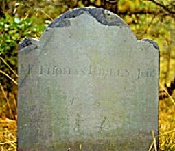
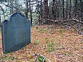
The first two photos were taken in 1993 by an unknown person.
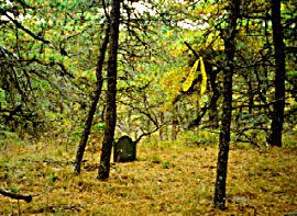
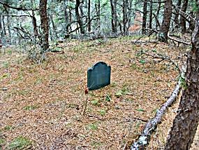
The next two photos were taken in 2008 by Cheryl Currier who found the long lost stone.
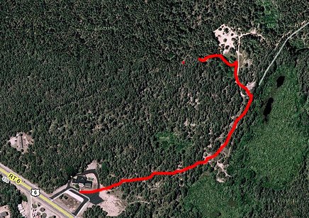
The aerial photo in the third row down represents an unsuccessful attempt by Nick Carr to find the stone. The photo is from his website www.Scoutingny.com. Montano's is at the lower left. The red line shows approximately where Nick searched.
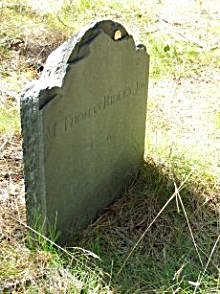
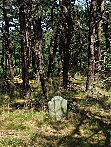
In April 2011 Christopher Setterlund found the stone and provided the two photos in the fourth row down.
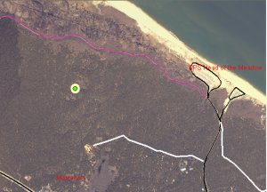
In August 2011 Mark Esposito provided the picture in the fifth row down. The green dot shows the location of the Ridley stone. Montanos and Route 6 are at the bottom left. The white line extending from the right to the middle is a private road extending back from a private campground.
The GPS coordinates for the stone are known but not reported here to make it more of a challenge to find the stone.
Directions to the gravestone written in 1993 have not been helpful in finding the stone over the last fifteen years. The 1993 directions were: "From Montano's Restaurant..park at back right of parking lot: old road goes off to left; at fork go left...follow trail to where piles of brush are...just before old sand pit take trail to the left up a hill. At the top of the hill the trail splits... goes thru the woods east (right). Follow the trail a little over 1/4 mile in and go left off trail into woods where yellow tape is on both sides. The gravestone is on a lower ridge to the left between two small fairly deep valleys.
In September 2008, Cheryl Currier found the stone after much searching! She indicates the location of the stone probably is beyond the top of the aerial photo and slightly to the right of the sand pit. Her description is as follows: The route I used to find it was to start at the top of the sand pit and go right following an old fire road (now just an overgrown trail). I took this until it petered out and then bore off left through the woods until I came to several deep valleys (kettle holes caused by the glaciers receding eons ago). I went around one by going to the right and then came back left further on between two kettle holes and there it was. The way I came out of the woods seemed more like the directions from 1993. I came back headed towards Route 6 which I could hear in the distance. Kept trekking until I hit that old fire road that runs down the side of the sand pit to the west. Then followed that down to the dirt road which leads west back out to Montano's.
In March 2011 two intrepid Cape Cod Times reporters, Eric Williams & Jason Kolnos, trekked thru the forest and over the dunes and found the stone. They published a story and posted an award winning online video about the lonliest gravestone on Cape Cod.
Thomas Ridley was born in Truro December 3, 1715. He was a farmer and fisherman. He married Elizabeth Cook and they had 10 children. He died of smallpox in 1776. Elizabeth died in 1792 at age 74. She is buried in Provincetown Cemetery Number 1. His father Thomas Sr. died 1767 and his son Thomas 3d died 1777. Both are buried in Truro Old North Cemetery.
Shebnah Rich in his 1883 book "Truro, Cape Cod or Landmarks and Sea Marks" on page 209 states Thomas Ridely died of smallpox in 1776 and when Shebnah visited the grave the headstone lay scattered in fragments. Perhaps the broken stone reported by Shebnah was a headstone now gone and the stone shown above is a footstone. However,the stone looks much larger than a typical footstone.
The name "RIDEEY" on the stone most likely is a carver error.
In 2012 Scott Ridley provided the following information: "The grave is on land that was a 30 acre family farm where Thomas raised sheep and cattle in addition to his fishing. The small bluff to the east of the grave, overlooking the marsh and ocean, was known as Ridley's Bank. Smalley's Bank was the bluff to the north, and Dyer's Bank to the south. Both families were intermarried with the Ridleys. Thomas was a smallpox victim and, as was the practice, he was not carried to the graveyard."
While he does not want to dicourage visitors, Scott cautions (as is well known to North Truro natives) that the area has rabid bats nesting in the holows and pines, hordes of dangerous deer ticks, vicious fisher cats, poisonous voles and Cape Cod vipers known to leap from the trees.
| Truro Isolated Burial Sites | Cemetery List | Home |